A 400-mile Journey from the Blue Ridge Mountains to the Atlantic Ocean...
From Revolutionary times until the advent of railroads the Savannah River was an important transportation corridor. Today it is a source of water for drinking and industrial use, a vehicle for waste disposal, and a force for power generation. Dams have created huge lakes where people fish, boat, wind surf, etc. on the waters of the Savannah.
The headwaters of the Savannah River originate in the mountains of North Carolina, South Carolina and Georgia near Ellicott Rock, the point where the three states meet. In the western part of the upper basin the Chatooga and the Tallulah Rivers meet to form the Tugaloo River. In the eastern part, the confluence of Twelve Mile Creek and the Keowee River form the Seneca River. In the upper reaches of Lake Hartwell the Seneca and Tugaloo Rivers join to form the Savannah River.
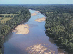
From its headwaters to the Atlantic Ocean (near Savannah, Georgia) the Savannah River travels about 300 miles and drains a watershed of 10,577 square miles. It flows through four physiographic regions: Blue Ridge Mountains, Piedmont, upper coastal plain and lower coastal plain. Ecosystems within the basin include agricultural systems, upland forests, bottomland hardwoods, pine plantations, free flowing streams, water impoundments (dams), swamps, and freshwater and marine marshes. Much of the water in the upper basin is retained in several large dams, including those forming Lake Hartwell, Lake Russell and Lake Thurmond. The lower part of the basin is characterized by a meandering course with few tributaries and slow currents. Tidal action influences water levels and flows about 45 miles upriver from the mouth.